
Atlas.co
Atlas.co · Other
Atlas.co is an AI GIS platform. Its Navi assistant builds maps, dashboards, and spatial apps from a conversation, so teams skip desktop GIS training.
About Atlas.co
What Is Atlas.co
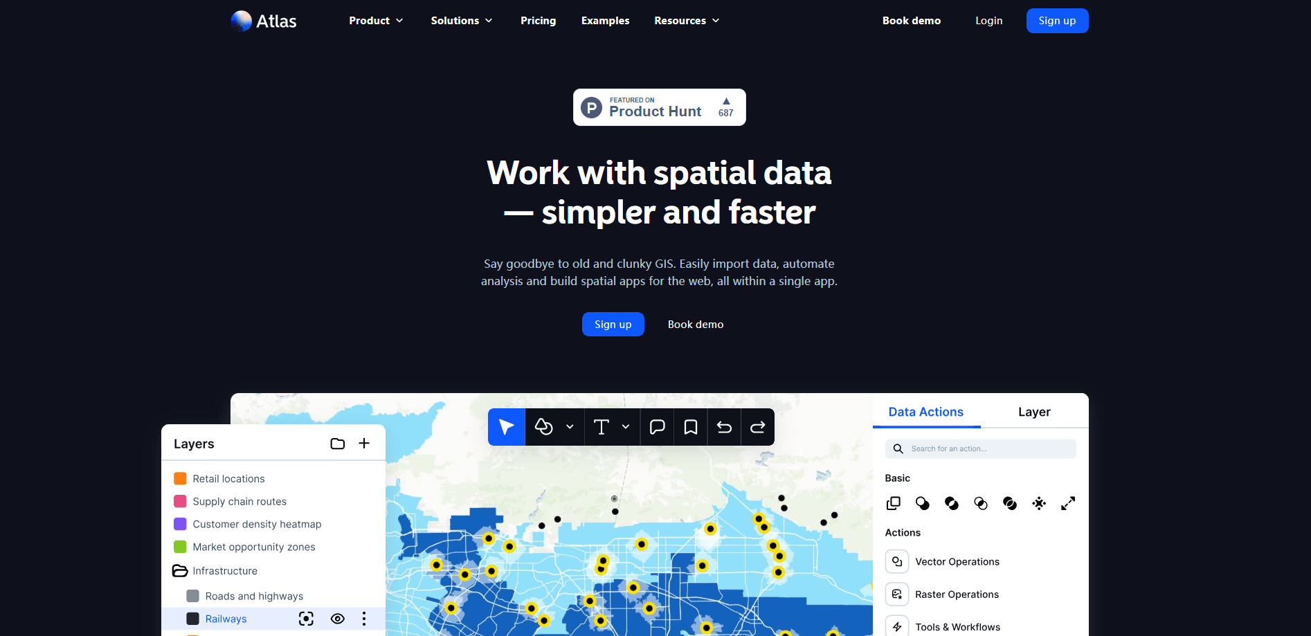
Atlas.co is a geographic information system that runs in the browser and builds itself from a conversation. Navi, the platform's AI assistant, takes a plain request like "map a real estate portfolio" or "run a site selection for wind farms in the UK," then produces a live map, a dashboard, or a working spatial app. The company markets it as the first GIS where the map comes out of a chat instead of a course or a desktop install.
The pitch is aimed at two crowds at once. GIS professionals get the standard toolkit: layers, styling, geocoding, 3D scenes, and connections to the databases they already trust. Everyone else, meaning operations leads, energy analysts, and property teams, gets the same output without learning ArcGIS. That mix is the product's whole bet.
The limits are worth naming early. Atlas.co is a browser tool for teams, not a free playground, and the Starter plan caps editors at three. Heavy geoprocessing, offline field work, and the deep raster analysis that desktop suites do are not the focus here. If you need those, Atlas.co becomes a companion rather than a replacement.
Getting Started
- Create an account from the Atlas.co website and open a new project.
- Connect a source, such as PostgreSQL, Google Sheets, Airtable, or a CSV file, and let it sync live.
- Tell Navi what you want built, then refine the layers, styling, and filters by hand.
- Save the views your team needs as bookmarks, then share the map or dashboard with a link.
Product Information
A quick look at Atlas.co's pricing, supported platforms, and performance.
Best for
The users, tasks, and scenarios where this tool fits best.
Users
- GIS analysts
- Operations and field teams
- Energy, infrastructure, and real-estate teams
- Startups and small companies
Tasks
- Building maps from conversation
- Site selection
- Portfolio and asset mapping
- Connecting scattered data
Scenarios
- A property team maps its whole portfolio from a spreadsheet, then shares the dashboard with investors through a link.
- An energy analyst runs site selection for new wind farms and reviews candidate parcels on a 3D scene.
- A city parks department tracks tree inspections and plots each task on a maintenance map.
- A utility crew connects a live database so the field map always shows the latest asset status.
Key features
Navi, the Conversational AI
Navi is the piece that sets Atlas.co apart. You type or speak a request in plain language, and Navi returns a map, a dashboard, or a working app with the right layers, filters, and pieces already in place. It handles prompts like a tree management dashboard or a site selection for wind farms, then hands you something editable. You can keep chatting to adjust it, and every teammate can edit the same result.
Live Data Connections
Atlas.co pulls scattered sources onto one canvas. It connects to PostgreSQL, BigQuery, Snowflake, Databricks, MySQL, SQL Server, and Oracle, plus Google Sheets, Airtable, Smartsheet, and plain CSV files. REST API endpoints, OGC web services, and ArcGIS Feature Servers are supported as well. Automatic sync keeps the map current, so changes in the source data show up without a manual re-import.
Interactive Web Map Viewer
The viewer runs in any browser with no desktop install or plugin. You pan, zoom, and explore spatial data, save bookmarks for the views that matter, and overlay your own annotations. A basemap gallery covers standard, light, dark, and satellite styles, and OpenStreetMap data is available inside your projects. Custom basemaps and external tile services cover anything the gallery misses.
3D Scenes and Advanced Visualization
A 3D scene viewer extrudes buildings by floor count, renders terrain, and lets you inspect a map from any angle. Styling tools go well beyond flat points: choropleth maps, proportional symbols, heatmaps, clustering, and 500+ built-in icons. There's a georeferencer for scanned maps and PDFs, drawing and measurement tools, and bulk geocoding for thousands of addresses at once.
Wide Format and Import Support
Drag-and-drop upload handles GeoJSON, Shapefile, KML, GeoPackage, GDB, GeoTIFF, CSV, and Excel files, along with 30+ formats in total. Vector, raster, and tabular data all land the same way, which shortens the gap between raw files and a finished map. NASA Earthdata integration adds satellite imagery from MODS, Landsat, and other programs.
API and Extensibility
REST API connections let you pull data from any JSON, GeoJSON, CSV, or NDJSON endpoint, and the platform's own API ties maps into other tools. You can bring custom basemaps and connect external tile services, so Atlas.co fits a larger data stack instead of standing alone. That matters for teams that already run pipelines elsewhere.
Pros and cons
Pros
- Navi turns a plain-language request into a usable map or dashboard, which cuts the setup time on a new project.
- Live connections to databases and spreadsheets keep maps current without manual re-imports.
- The same workspace serves GIS specialists and non-specialists, so both audiences edit one shared map.
- A wide import range and OGC and ArcGIS connections fit teams already using enterprise GIS data.
- 3D scenes, geocoding, and styling tools cover more ground than most browser-based alternatives.
Cons
- There's no free plan, and the Starter tier limits editors to three, so trying it means paying.
- Pricing is not public, so you have to contact the team to size a plan for a larger group.
- Deep raster analysis and offline field work sit closer to desktop GIS suites than to this browser tool.
- The AI-first layout may feel indirect to veteran GIS users who prefer to build layers by hand from the start.
Frequently asked questions
Atlas.co builds maps, dashboards, and spatial apps in the browser. Teams use it to pull scattered data onto one live map, run site selection, and track assets like properties, turbines, or trees without a desktop GIS install.
Related content
Explore related tools, skills, and articles for Atlas.co.
Atlas.co Alternatives
BinkBink
BinkBink · OtherBinkBink is a free online game platform and AI game maker that lets anyone turn a short text description into a playable browser game. You can jump into hundreds of community-made games. Or describe your own idea and play it in seconds, then share it with friends. Want to create your own game? You don't need to code. No engine setup, no download, no hassle.

Audiogen
Audiogen Inc. · OtherAudiogen is an AI music generator built by Audiogen Inc., a small research team that spent about 2.5 years training its own generative music model and designing a web interface around it. Instead of a plain text box, this AI music tool turns the timeline into a beginner-friendly Generative Audio Workstation, or GAW, where inpainting, extending, remixing and stem editing work more like painting on a canvas. The product is still in beta, so access runs through a waitlist or an invite. Paid plans aren't published yet.

Aiml API
AIMLAPI OÜ · OtherAiml API is a unified AI model API that puts more than 1000 models from OpenAI, Google, Anthropic, and others behind one endpoint and one bill. You write code against a single OpenAI-compatible schema, then switch between chat, image, video, and audio models by changing a model string. It suits developers and small teams who want multi-model access without juggling a dozen separate provider accounts, and it removes the usual billing headache that comes with testing several vendors. One key covers it all.